Geospatial Characteristics of Program Beneficiaries (Documentation)
BACOU, Melanie for AgResults (Abt Associates)
Last updated on 2017-09-16. DO NOT USE OR CITE
Section 1 Survey Sampling
These pages document data sources and methods used to generate detailed spatially-referenced characteristics of farm households interviewed as part of AgResults 2015-2017 program evaluation in Nigeria, Kenya, and Uganda.
All statistics are derived using the geospatial locations of surveyed respondents. However these locations are sometimes missing or invalid. In the case of missing coordinates we generate spatial statistics at the centroid of the matching administrative unit (the lowest level unit that may be mapped with any confidence, i.e. LGA for Nigeria, county for Kenya, and district for Uganda). Note that another approach would be to derive average statistics over the entire administrative unit, however this approach is more resource-intensive.
1.1 Nigeria
2,065 households are sampled in Nigeria. There are 81 households missing coordinates and 414 possibly invalid locations.
| Nigeria Household GPS Locations | ||||
|---|---|---|---|---|
| State | LGA | Obs. | Missing | Invalid |
| Kaduna | Birnin-Gwari | 133 | 3 | 10 |
| Chukun | 3 | 1 | 2 | |
| Giwa | 151 | 26 | 17 | |
| Igabi | 7 | 0 | 0 | |
| Ikara | 84 | 3 | 11 | |
| Jema’a | 54 | 9 | 18 | |
| Kaura | 12 | 7 | 0 | |
| Kauru | 22 | 0 | 5 | |
| Kubau | 160 | 0 | 23 | |
| Kudan | 49 | 4 | 18 | |
| Lere | 62 | 1 | 0 | |
| Makarfi | 109 | 3 | 28 | |
| Rogo | 20 | 0 | 1 | |
| Sabon Gari | 29 | 0 | 20 | |
| Soba | 157 | 0 | 0 | |
| Zaria | 21 | 4 | 17 | |
| All | 1,073 | 61 | 170 | |
| Kano | Bebeji | 34 | 1 | 3 |
| Bunkure | 19 | 0 | 0 | |
| Dawakin Kudu | 14 | 1 | 8 | |
| Doguwa | 35 | 0 | 0 | |
| Gwarzo | 40 | 1 | 3 | |
| Karaye | 39 | 2 | 0 | |
| Kibiya | 9 | 0 | 0 | |
| Kiru | 14 | 1 | 0 | |
| Kura | 10 | 0 | 0 | |
| Rano | 10 | 0 | 0 | |
| Rimin Gado | 16 | 0 | 13 | |
| Rogo | 31 | 0 | 0 | |
| Tofa | 5 | 0 | 0 | |
| Tudun Wada | 83 | 8 | 0 | |
| All | 359 | 14 | 27 | |
| Katsina | Bakori | 256 | 2 | 93 |
| Danja | 90 | 0 | 18 | |
| Funtua | 83 | 1 | 24 | |
| Kahur | 71 | 2 | 37 | |
| Malumfashi | 113 | 1 | 35 | |
| Sabuwa | 20 | 0 | 10 | |
| All | 633 | 6 | 217 | |
| All | 2,065 | 81 | 414 | |
There are 414 households with GPS coordinates that do not fall within their recorded LGA. In the majority of instances the distance is negligeable (under 10km) and this might not affect any of the spatial estimates. In a few instances the errors are troublesome (over 40km). For documentation purposes households with problematic locations are highlighted on the map below.
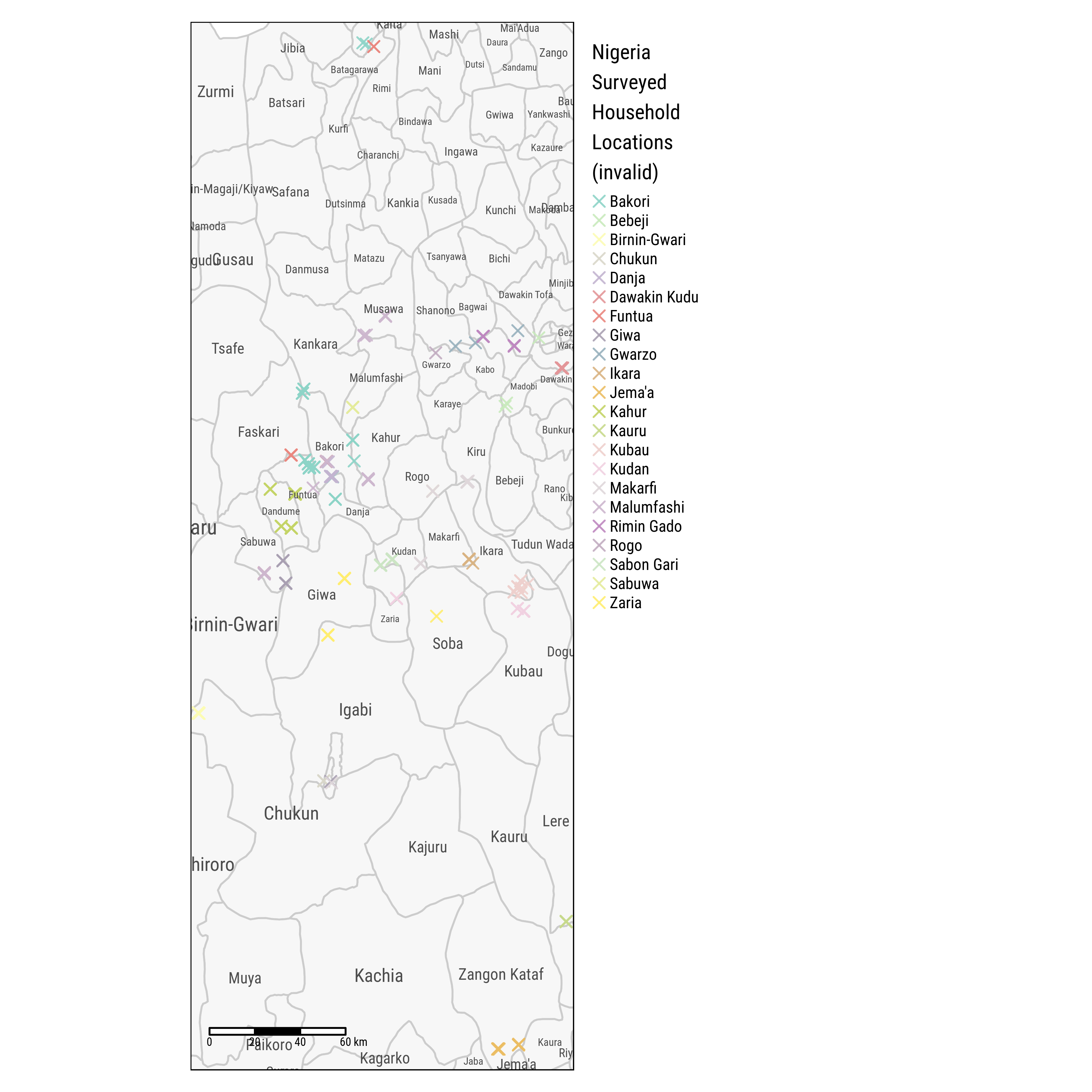
Fig. 1.1: Households with Invalid GPS Locations, Nigeria
1.2 Kenya
In Kenya data was collected over 2 rounds with some attrition, and household locations do not necessarily match across rounds. We use a general approach to impute missing, invalid, and/or conflicting coordinates:
- if both GPS locations seem valid (i.e. they are located in the reported county), we use their middle point (coded
meanin table below) - if only 1 of the 2 locations is valid, we use that one (coded
bl1orbl2) - if no location is valid (both fall outside of a recorded administrative unit), we use that administrative unit centroid (coded
centroid).
5,235 households are sampled in Kenya. There is a total of 88 households with missing or invalid coordinates. Table below shows a breakown of imputed household locations across Kenya’s 8 regions and 47 counties. Note that we could not locate a map of Kenya’s sub-counties.
| Kenya Household GPS Locations | ||||||
|---|---|---|---|---|---|---|
| Status | ||||||
| Region | County | centroid | bl2 | bl1 | mean | All |
| Central | Kirinyaga | 3 | 1 | 4 | ||
| Murang’a | 1 | 1 | ||||
| All | 4 | 0 | 0 | 1 | 5 | |
| Coast | Kilifi | 1 | 1 | |||
| Taita Taveta | 1 | 1 | ||||
| All | 2 | 0 | 0 | 0 | 2 | |
| Eastern | Embu | 124 | 259 | 582 | 965 | |
| Kitui | 11 | 151 | 247 | 583 | 992 | |
| Machakos | 13 | 17 | 111 | 737 | 878 | |
| Makueni | 4 | 78 | 192 | 601 | 875 | |
| Meru | 13 | 69 | 208 | 624 | 914 | |
| Tharaka | 7 | 7 | ||||
| All | 48 | 439 | 1,017 | 3,127 | 4,631 | |
| Nairobi | Nairobi | 1 | 1 | |||
| All | 1 | 0 | 0 | 0 | 1 | |
| Rift Valley | Baringo | 7 | 7 | 53 | 67 | |
| Bomet | 14 | 12 | 15 | 45 | 86 | |
| Kajiado | 1 | 1 | ||||
| Kericho | 11 | 31 | 42 | |||
| Laikipia | 12 | 49 | 61 | |||
| Nakuru | 7 | 5 | 55 | 67 | ||
| Nandi | 5 | 1 | 9 | 50 | 65 | |
| Narok | 6 | 21 | 41 | 22 | 90 | |
| Trans Nzoia | 1 | 8 | 51 | 60 | ||
| Uasin Gishu | 1 | 5 | 51 | 57 | ||
| All | 33 | 43 | 113 | 407 | 596 | |
| All | 88 | 482 | 1,130 | 3,535 | 5,235 | |
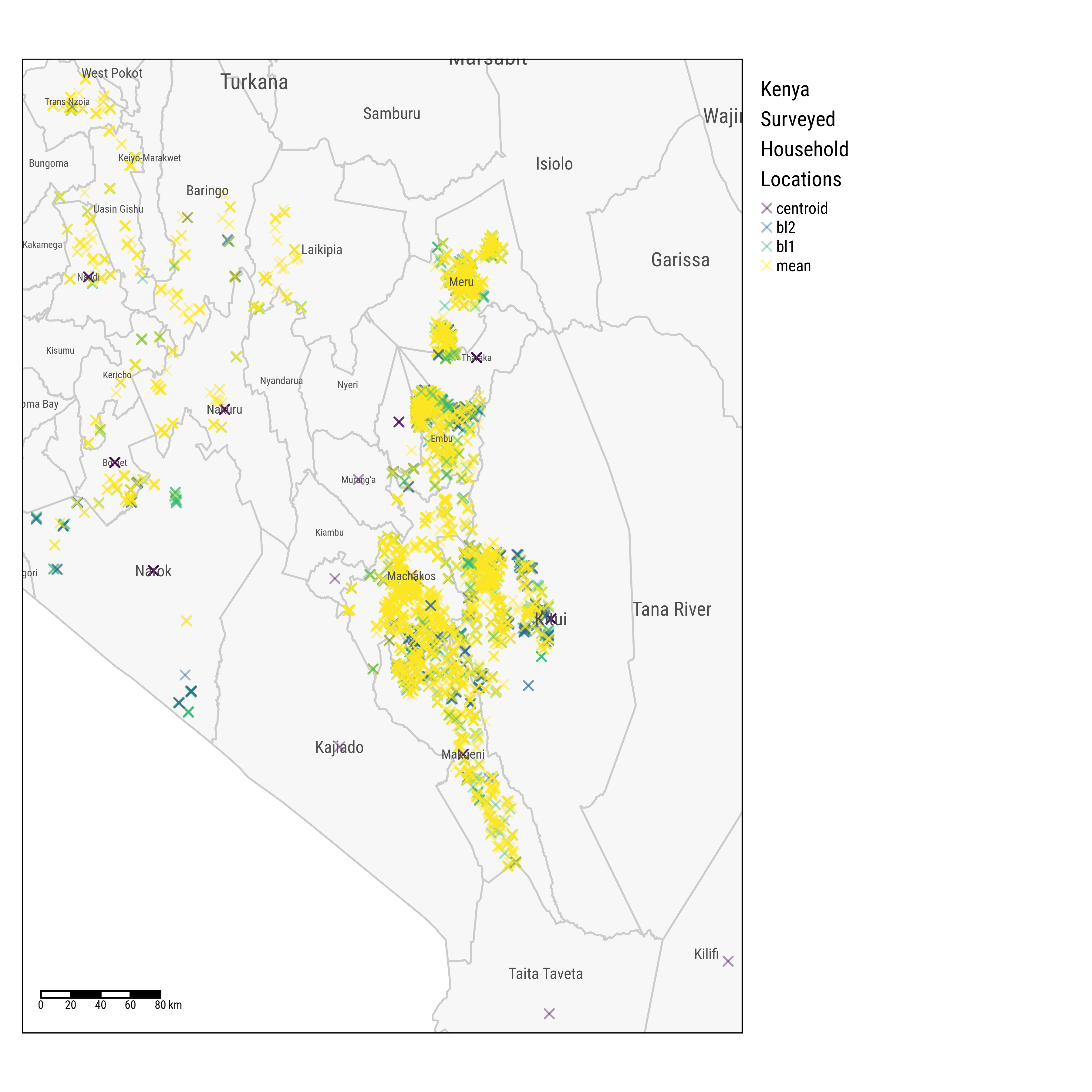
Fig. 1.2: Households Locations across Counties, Kenya
1.3 Uganda
1,479 households are sampled in Uganda. There are 55 households missing coordinates. Missing coordinates are imputed using village centroids (these imputed locations are shown on the map below in red).
| Uganda Household GPS Locations | |||
|---|---|---|---|
| District | County | Obs. | Missing |
| Amuria | Amuria County | 9 | 0 |
| Kapelebyong County | 20 | 0 | |
| All | 29 | 0 | |
| Amuru | Kilak County | 142 | 3 |
| All | 142 | 3 | |
| Apac | Kwania County | 19 | 0 |
| All | 19 | 0 | |
| Arua | Ayivu County | 20 | 4 |
| Madi-Okollo County | 10 | 3 | |
| Terego County | 10 | 3 | |
| All | 40 | 10 | |
| Bushenyi | Bushenyi-Ishaka Municipality | 9 | 0 |
| Igara County East | 10 | 0 | |
| Igara County West | 30 | 0 | |
| All | 49 | 0 | |
| Gulu | Aswa County | 29 | 0 |
| Omoro County | 29 | 0 | |
| All | 58 | 0 | |
| Isingiro | Bukanga County | 8 | 2 |
| Isingirocounty North | 29 | 6 | |
| All | 37 | 8 | |
| Kabale | Ndorwa County East | 20 | 4 |
| Ndorwa County West | 20 | 4 | |
| Rubanda County East | 21 | 4 | |
| Rubanda County West | 9 | 2 | |
| All | 70 | 14 | |
| Kabarole | Bunyangabu County | 19 | 0 |
| Burahya County | 9 | 0 | |
| Fortportal Municipality | 21 | 0 | |
| All | 49 | 0 | |
| Kamuli | Bugabula County South | 10 | 0 |
| All | 10 | 0 | |
| Kanungu | Kinkinzi County West | 10 | 2 |
| All | 10 | 2 | |
| Kasese | Bukonjo County West | 10 | 0 |
| Busongora Countynorth | 19 | 0 | |
| Kasese Municipality | 9 | 0 | |
| All | 38 | 0 | |
| Kibaale | Buyagaeast County | 40 | 0 |
| Buyagawest County | 20 | 0 | |
| Buyanja County | 19 | 0 | |
| All | 79 | 0 | |
| Kiruhura | Kazo County | 10 | 0 |
| Nyabushozi County | 20 | 0 | |
| All | 30 | 0 | |
| Kyenjojo | Mwenge County North | 23 | 0 |
| Mwenge County South | 26 | 3 | |
| All | 49 | 3 | |
| Luweero | Katikamu County North | 10 | 0 |
| All | 10 | 0 | |
| Masaka | Bukoto County Central | 47 | 0 |
| Bukoto County East | 13 | 0 | |
| Masaka Municipality | 21 | 0 | |
| All | 81 | 0 | |
| Masindi | Bujenje County | 19 | 0 |
| Buruli County | 16 | 0 | |
| All | 35 | 0 | |
| Mbale | Bungokho County North | 20 | 0 |
| Bungokho County South | 40 | 0 | |
| All | 60 | 0 | |
| Mityana | Mityana County South | 10 | 0 |
| All | 10 | 0 | |
| Mubende | Buwekula County | 30 | 0 |
| Kasambya County | 65 | 0 | |
| Kassanda County North | 40 | 0 | |
| Kassanda County South | 44 | 0 | |
| All | 179 | 0 | |
| Mukono | Mukono County South | 10 | 0 |
| All | 10 | 0 | |
| Namutumba | Busiki County | 10 | 0 |
| All | 10 | 0 | |
| Ntungamo | Kajara County | 72 | 0 |
| Ruhaama County | 67 | 0 | |
| Rushenyi County | 27 | 0 | |
| All | 166 | 0 | |
| Oyam | Oyam County North | 84 | 6 |
| Oyam County South | 73 | 4 | |
| All | 157 | 10 | |
| Pader | Aruu County | 10 | 0 |
| All | 10 | 0 | |
| Wakiso | Kyadondo County North | 21 | 0 |
| All | 21 | 0 | |
| Yumbe | Aringa County | 21 | 5 |
| All | 21 | 5 | |
| All | 1,479 | 55 | |
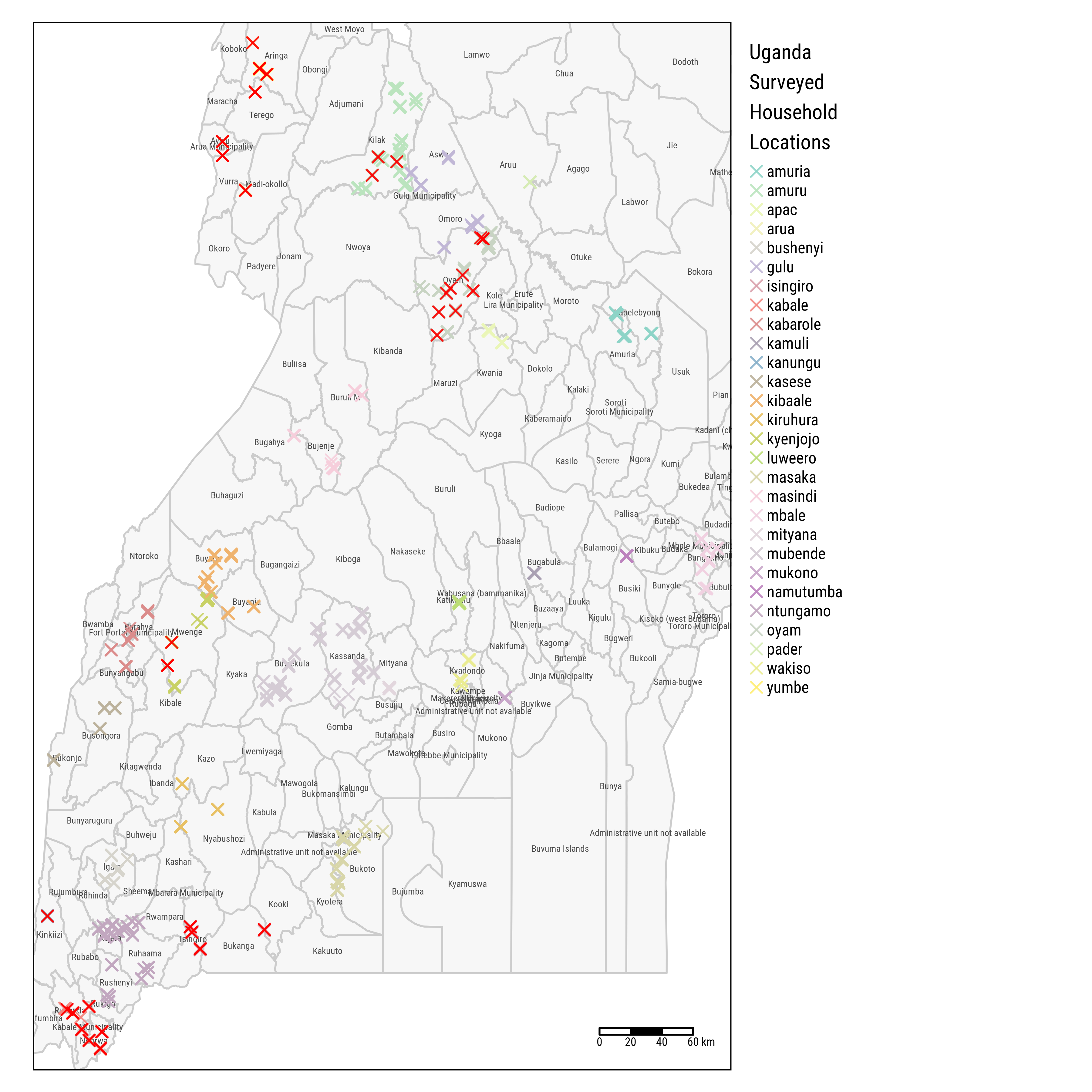
Fig. 1.3: Households Locations across Districts, Uganda